
SIREVA eMUSTERING
BLE Bracelet for Indoor Locating
Safety technology offers diverse applications for locating people. Therefore, the existing technologies and algorithms are very diverse as well. The satellite positioning system GPS is the established solution for localization outside of buildings and has been successfully used for years. However, because of the signal reduction, GPS is generally not usable inside buildings. In this case, real-time locating systems based on radio-locating systems are employed.
This is where we start with our locating system, which is based on the Bluetooth Low Energy technology. Compared to normal Bluetooth, BLE has significantly lower power consumption, which means that the batteries in the modules only have to be changed very rarely. Like normal Bluetooth, BLE transmits in the 2.4GHz-range. Depending on the environmental conditions, the BLE-tags can achieve a range of 60 meters.
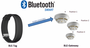
The ATS BLE-tag is an electronic BLE-transmission unit which sends advertising packets or information about its identity electronically. The BLE-tag sends advertising packets periodically in preset intervals and adjustable transmission power. One packet contains UUID (16 bytes), major-id (2 bytes), minor-id (2 bytes), RSSI value und RSSI reference value.
When the range of a BLE-tag reaches an ATS-Gateway, it can recognize the identity of the sender and transmit that information including Received Signal Strength Indicator (RSSI).
With this information, the locating system can calculate presence and position.
The combination of BLE-tag, BLE-gateway and the locating software, which calculates location by means of different algorithms (e.g. proximity/neighbor analysis, Myra) provides for a perfect solution to the problem of locating resources in real time.
It is the objective of the ATS-Real-Time-Locating-System to control and initiate further processes in real time. The availability of the location information is being secured within a set timeframe and written into the appropriate database.
BLE Gateway
The BLE-Gateway, which has been developed by ATS, is a transceiver that reads and transmits BLE advertising packets.
Pursuing the goal of developing an adaptive gateway unit, three different series have been produced. The A-Series uses a WiFi-Transmitter and is used in dynamic environments allowing easy Plug and Play concepts without the prerequisite of a given cable infrastructure. Moreover, crew members are able to search for passengers connected to a mobile WiFi-gateway.
In contrast, the B- and C-Series were developed to be integrated into a predefined environment. The B-Series is equipped with an Ethernet-Port (POE) to transmit the received data and to assure a fail-safe operation and a 24/7 service.
The C-Series works with a RS485 four-wire bus, and is recommended to be used in low bandwidth environments.
For example:
As soon as a BLE tag is near a gateway (PTS055), the tag data is transmitted via Bluetooth Low Energy to the gateways.
After reading the received data with the gateway firmware, the gateways then transmit the data via a serial data bus (RS485) from the object to the tracking software (PTS2021). The Gateway works as an interface between BLE radio technology and tracking software. The data is transmitted from the gateway via a RS485 four-wire bus to the tracking software.
Next to the data transmission, which is done via differential serial voltage levels between the lines [A] and [B], the gateway is supplied with power via lines 3 and 4. This transmission technology allows us to achieve distances of 500m up to a maximum of 1200m with concurrent high transmission rates.
The locating software collects and analyses the received data packets from the gateways and deduces a position based on the results from its algorithm. In addition, the algorithm from the tracking software carries out a plausibility check. Taking into account the current reception quality in relation to the relevant gateway position, the received data is interpolated by several gateways, for higher accuracy of the tag positioning.
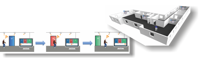
For the locating, it is necessary to give an ID to each gateway. The ID is sent along with the transmission. The IDs are assigned coordinates in an accompanying database to determine the exact position in an object. The core process (algorithm in the tracking software) uses this database to assign an exact position to each tag.
The accuracy of the locating is therefore dependent on, among other things, the number of gateways as well as the Bluetooth range inside the object (local conditions have to be taken into consideration).
The calculated location data is transported via OPC UA or MQTT to the people tracking logic unit. After that, the data is modified via MARSIG People Tracking Logic Unit, given an appropriate status, and visualized.
![]()
People Tracking Logic Unit
The People Tracking Logic Unit (PTL) closes the circle of the SIREVA eMustering system. Having imported the ship infrastructure, it not only visualizes the status of each passenger and zone, but does also fulfill the role of being a helping hand to all crew involved in an emergency situation.
The integrated control center and decision support system includes situation awareness offering a deck overview with appropriate map data, position of available life-saving appliances as well as crew capacities.
In addition to preconfigured ship data, the PTL receives position data from PTS2021 via MQTT which enables it to provide a live situation overview. Based upon the live position data, the PTL displays the progress of ongoing emergency operations, creates suggestions, supports crew member decisions, coordinates external personnel and sends information to the responsible shipping company.
Moreover, the software fulfills requirements of a security related application including access control, data security and an ergonomic operating concept.
In case of an emergency, the PTL is allowed to request data from the internal person data management system that combines usage of live and personal data. Depending on the duty role, the leading positions have their own tailor-made overviews to coordinate the evacuation and mustering of passengers. The core process keeps track of each zone of the ship, updates status information and visualizes live position data. Furthermore, it makes use of an implemented filter function that tolerates erratic movement of persons for a short period of time to avoid any confusion of the responsible personnel in control. Next to the automatic processing, the interactive GUI allows crew and captain to make decisions on their own.
Such decisions may include the identification of missing persons, passenger on wrong muster stations and supporting the handling of passengers with special needs.
Additional functionalities are under development and will provide additional values for shipping companies in the future.